Rural and urban statistics
The rural/urban classification was introduced in 2004 and defines the rurality of very small geographies. The classification has since been updated in 2011 and again in 2021 to account for the changes in the population identified in the 2011 and 2021 censuses. The most recently updated classification identifies six main settlement types with 'nearer to a major town or city' and 'further from a major town or city' replacing the 'sparsity' classification that was used in 2011.
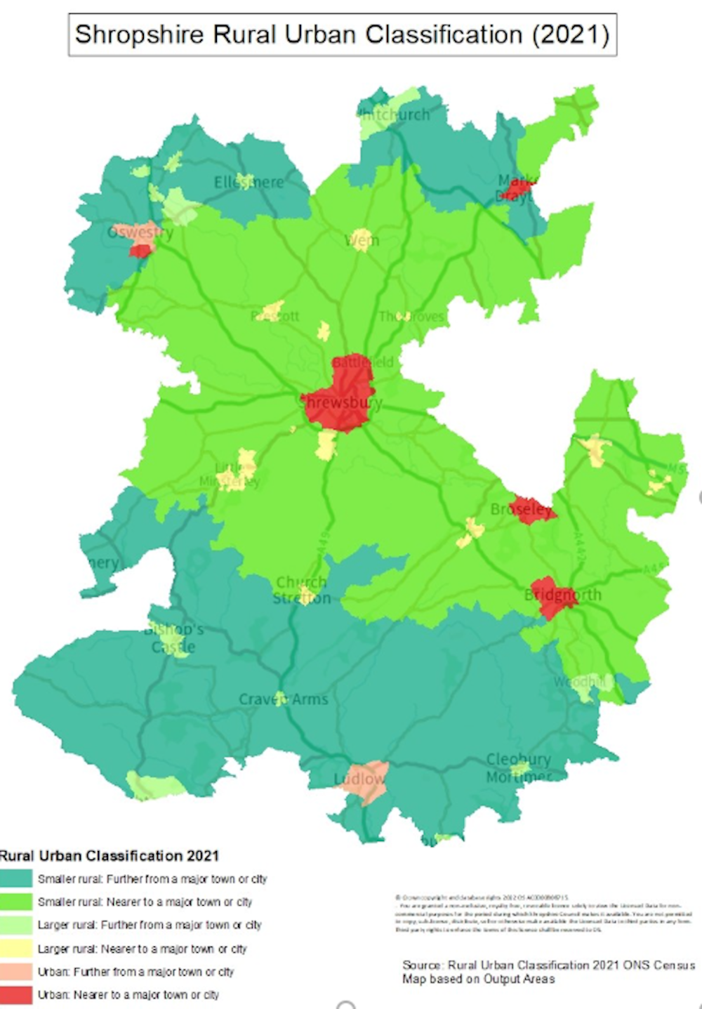
Most of the population in Shropshire live in rural locations, at 57.39% of the total. Of the 42.61% of the population that live in urban areas, most live in 'urban: nearer to a major town or city'. In this context, with a population of more than 75,000, Shrewsbury is classified as a major town. Other than Shrewsbury, Oswestry, Market Drayton, Broseley, Bridgnorth and Ludlow are the main urban centres. Ludlow and parts of Oswestry are classed as 'further from a major town or city' as they're not within a 30-minute journey by road of either Shrewsbury or an alternative non-Shropshire major town or city. The urban areas of Shropshire account for less than 3% of land mass.
More Shropshire residents live in the most rural areas ('smaller rural') than in the more densely populated rural areas ('larger rural'), and 60% of all those living rurally are classed as living 'nearer to a major town or city'. More than 94% of Shropshire’s land mass is classified as 'smaller rural'.
Breakdown of Shropshire population and land mass based on rural urban classification
- Description
Urban: nearer to a major town or city
- % of population
-
33.90%
- % of land mass
-
2.04%
- Description
Urban: further from a major town or city
- % of population
-
8.71%
- % of land mass
-
0.69%
- Description
Total urban
- % of population
-
42.61%
- % of land mass
-
2.73%
- Description
Larger rural: nearer to a major town or city
- % of population
-
11.55%
- % of land mass
-
1.18%
- Description
Larger rural: further from a major town or city
- % of population
-
10.69%
- % of land mass
-
1.78%
- Description
Smaller rural: nearer to a major town or city
- % of population
-
22.94%
- % of land mass
-
50.07%
- Description
Smaller rural: further from a major town or city
- % of population
-
12.21%
- % of land mass
-
44.25%
- Description
Total rural
- % of population
-
57.39%
- % of land mass
-
97.27%
Source: Rural Urban Classification 2021, ONS Mid-year population estimates 2022
Note:
- Major town or city defined as a built-up area with at least 75,000 usual residents
- 'Nearer to a major town or city' – residents can access within 30 minutes of travel by road
- 'Further from a major town or city' – residents can't access within 30 minutes of travel by road
The following tables show the breakdown of the population according to rural urban classification in Shropshire compared with England and Wales...
% of population
- Rural/urban?
Rural
- Shropshire
57.4%
- England and Wales
17.5%
- Rural/urban?
Urban
- Shropshire
42.6%
- England and Wales
82.5%
% of land mass
- Rural/urban?
Rural
- Shropshire
97.7%
- England and Wales
84.5%
- Rural/urban?
Urban
- Shropshire
2.3%
- England and Wales
15.5%
Source: Rural Urban Classification 2021, ONS Mid-year population estimates 2022
Shropshire is a sparsely populated county, with just over one person on average per hectare comped with four persons across England. The rural part of Shropshire has just 0.6 persons per hectare compared with 16.01 persons in the urban areas.
Population density based on rural/urban classification - persons per hectare
- Location
Urban: nearer to a major town or city
- Persons per hectare
-
17.06
- Location
Urban: further from a major town or city
- Persons per hectare
-
12.92
- Location
Total urban
- Persons per hectare
16.01
- Location
Larger rural: nearer to a major town or city
- Persons per hectare
-
10.06
- Location
Larger rural: further from a major town or city
- Persons per hectare
-
6.15
- Location
Smaller rural: nearer to a major town or city
- Persons per hectare
-
0.47
- Location
Smaller rural: further from a major town or city
- Persons per hectare
-
0.28
- Location
Total rural
- Persons per hectare
0.60
Source: Rural Urban Classification 2021, ONS Mid-year population estimates 2022
Detailed classifications
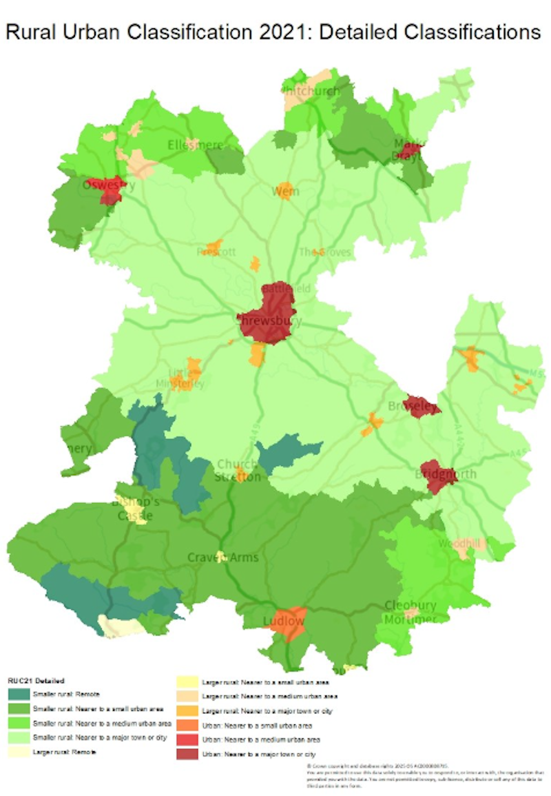
The 2021 rural urban classification also has a more detailed layer of classifications, splitting urban classifications into three ('nearer to a major town or city', 'nearer to a medium urban area' and 'nearer to a small urban area') and 'larger rural areas' and 'smaller rural areas' into four each ('nearer to a major town or city', 'nearer to a medium urban area', 'nearer to a small urban area' and 'remote').
Breakdown of Shropshire population and land mass based on rural/urban classification
- Location
Urban: nearer to a major town or city
- % of population
33.9%
- % of land mass
2.04%
- Location
Urban: nearer to a medium urban area
- % of population
-
5.44%
- % of land mass
-
0.28%
- Location
Urban: nearer to a small urban area
- % of population
-
3.27%
- % of land mass
-
0.41%
- Location
Total urban
- % of population
42.61%
- % of land mass
2.73%
- Location
Larger rural: nearer to a major town or city
- % of population
-
11.55%
- % of land mass
-
1.18%
- Location
Larger rural: nearer to a medium urban area
- % of population
-
9.10%
- % of land mass
-
1.13%
- Location
Larger rural: nearer to a small urban area
- % of population
-
1.55%
- % of land mass
-
0.31%
- Location
Larger rural: remote
- % of population
-
0.04%
- % of land mass
-
0.34%
- Location
Smaller rural: nearer to a major town or city
- % of population
-
22.94%
- % of land mass
-
50.07%
- Location
Smaller rural: nearer to a medium urban area
- % of population
-
4.12%
- % of land mass
-
9.85%
- Location
Smaller rural: nearer to a small urban area
- % of population
-
7.39%
- % of land mass
-
29.20%
- Location
Smaller rural: remote
- % of population
-
0.7%
- % of land mass
-
5.21%
- Location
Total rural
- % of population
57.39%
- % of land mass
97.27%
Source: Rural Urban Classification 2021, ONS Mid-year population estimates 2022
Note:
- Major town or city defined as a built-up area with at least 75,000 usual residents
- Medium urban area defined as maximum of 30,000 usual residents
- Small urban area defined as a maximum of 10,000 usual residents
- Remote: unable to reach a place of 10,000 people within 30 minutes
Population density based on detailed rural/urban classification
- Location
Urban: nearer to a major town or city
- Persons per hectare
17.06%
- Location
Urban: nearer to a medium urban area
- Persons per hectare
-
20.21
- Location
Urban: nearer to a small urban area
- Persons per hectare
-
8.08
- Location
Total urban
- Persons per hectare
16.01
- Location
Larger rural: nearer to a major town or city
- Persons per hectare
-
10.06
- Location
Larger rural: nearer to a medium urban area
- Persons per hectare
-
8.26
- Location
Larger rural: nearer to a small urban area
- Persons per hectare
-
5.17
- Location
Larger rural: remote
- Persons per hectare
-
0.11
- Location
Smaller rural: nearer to a major town or city
- Persons per hectare
-
0.47
- Location
Smaller rural: nearer to a medium urban area
- Persons per hectare
-
0.43
- Location
Smaller rural: nearer to a small urban area
- Persons per hectare
-
0.26
- Location
Smaller rural: remote
- Persons per hectare
-
0.14
- Location
Total rural
- Persons per hectare
1.02
Source: Rural Urban Classification 2021, ONS Mid-year population estimates 2022
Local authority classifications
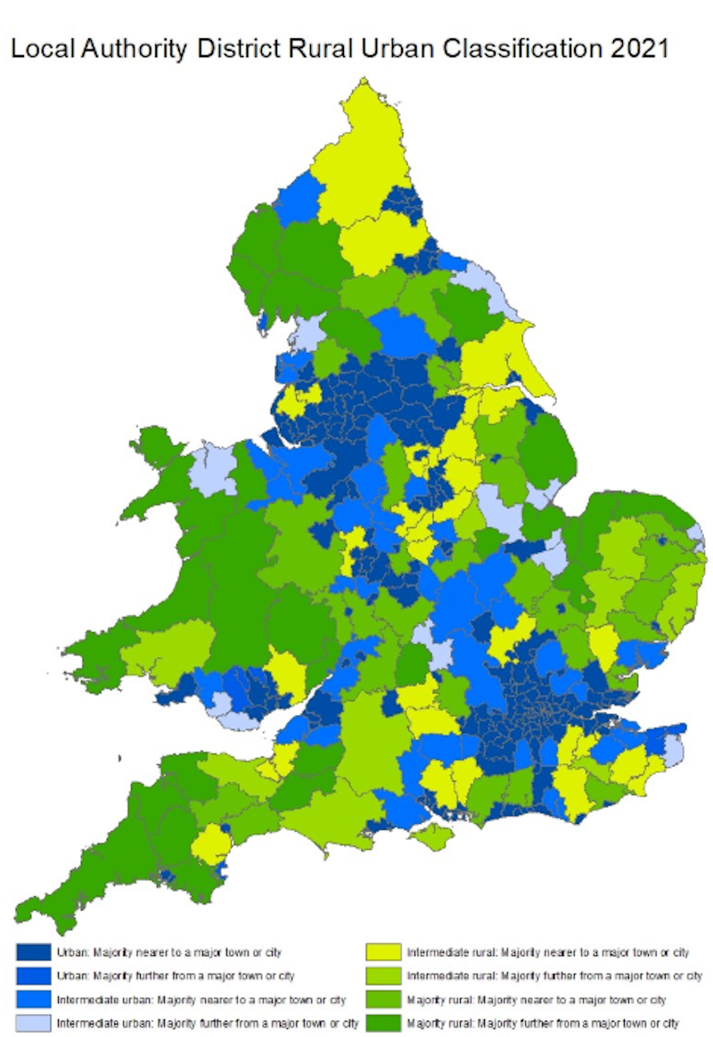
The RUC 2021 classifies local authorities according to eight classifications:
-
Urban: majority nearer to a major town or city
-
Urban: majority further from a major town or city
-
Intermediate urban: majority nearer to a major town or city
-
Intermediate urban: majority further from a major town or city
-
Intermediate rural: majority nearer to a major town or city
-
Intermediate rural: majority further from a major town or city
-
Majority rural: majority nearer to a major town or city
-
Majority rural: majority further from a major town or city
Shropshire is classified as 'majority rural: majority nearer to a major town or city'.
In terms of the proportion of the population that lives in rural output areas, Shropshire ranks amongst the top quintile of local authority districts in respect of rurality (ranking 41st out of 331 district, borough and unitary authorities).
Mapping
You can zoom in on the maps when you open them.