Car park locations and route maps
Shrewsbury Park and Ride really is the easy way into town, with three services - each with free its own free car park - conveniently located in Oxon, Meole Brace and Harlescott.
Here you can find detailed information about each Park and Ride service including car park information for each site, route maps and bus stop locations within the town centre.
General car park information
- Free parking is available at all Shrewsbury park and ride sites. You only pay per person for bus travel, with tickets purchased directly on board
- CCTV coverage is available at each site, although it's limited. Please note that vehicles are parked at your own risk. Shropshire Council and its subsidiaries can't accept responsibility for any damage or loss
- Closing times: Oxon and Meole Brace car parks are locked shortly after the final bus arrives from the town centre (approximately 6:40pm).
- All park and ride car parks are closed on Sundays and bank/public holidays
- No overnight parking: vehicles left in the car park after the last bus leaves may be locked in.
If this happens, call 0345 678 9006 to request release. A £60 (cash-only) call-out fee applies - Cycle parking is available at Meole Brace and Oxon sites
- Motorhomes are welcome, but height barriers will restrict access initially. Please speak to an Arriva staff member for assistance. Staff are usually based in the driver rest room near the main shelters. If a member of staff isn't present at the rest room, you'll need to await their return
- Service-only parking: these car parks are reserved for park and ride users. Parking without using the service requires prior permission from Shropshire Council.
For additional information please contact the Public Transport Team at buses@shropshire.gov.uk
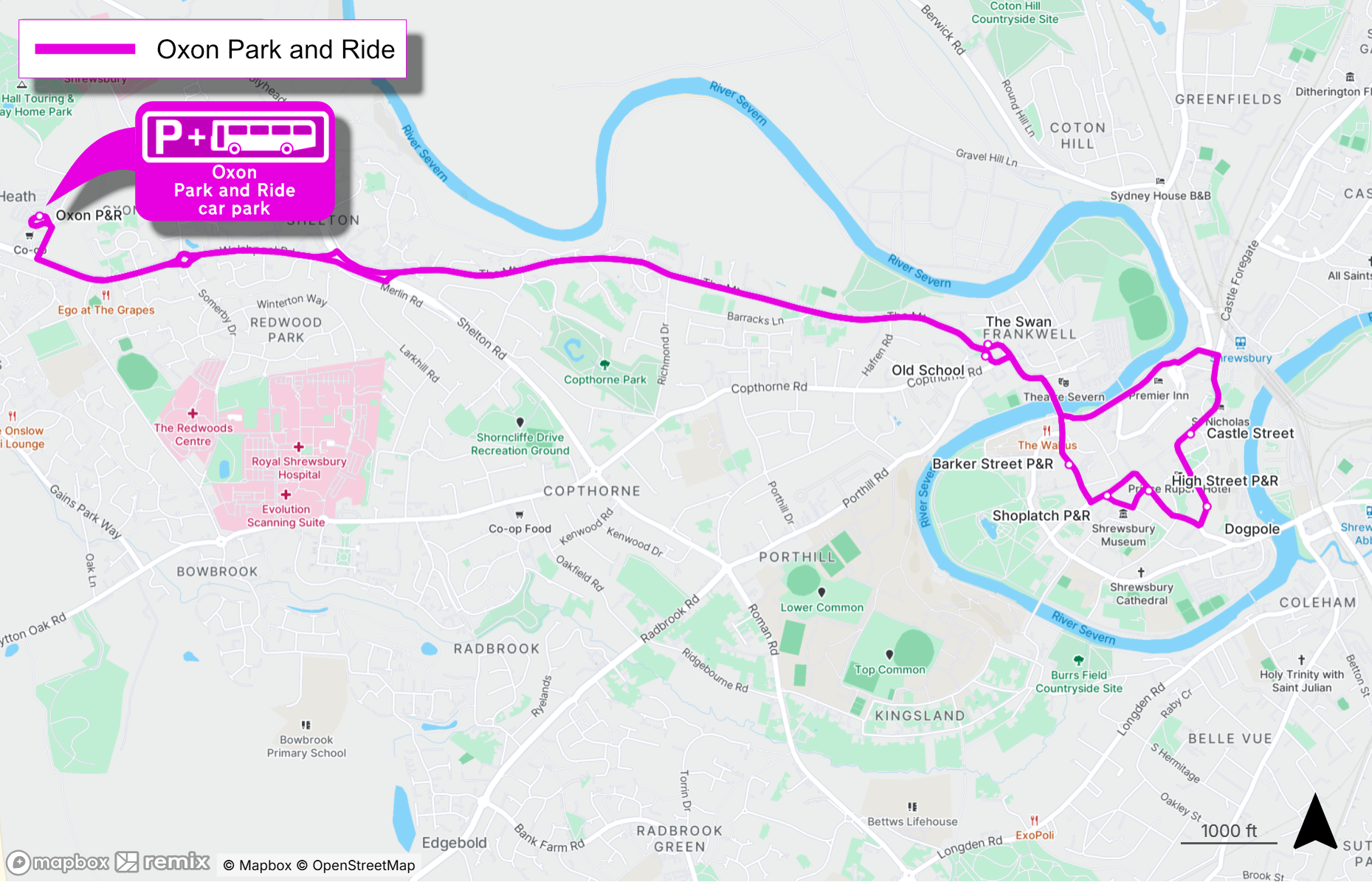
Oxon - Car park and route map
This Oxon Park and Ride site is located behind the Bicton Heath Co-operative and Greggs.
From the Shrewsbury bypass, turn on to the Welshpool Road following the signs for Oxon park and ride, turn left at the junction directly after the traffic lights outside the Co-op and continue towards the signed park and ride car park.
The nearest postcode to the Oxon site is SY3 5AD (Bicton Heath Retail Park, Shrewsbury).
The Oxon Park and Ride service stops at the following locations in Shrewsbury town centre. Click on each link to be taken to a Google Maps location for each stop:
- Frankwell
- Castle Street (the bus shelter outside ‘Dutch Living’ is for the Oxon and Harlescott services
- Dogpole
- High Street (The Square)
- Shoplatch (Market Hall)
- Barker Street (Rowley’s House)
- Frankwell (old school)
Take a look at the Oxon Park and Ride route map to view the full route for this service.
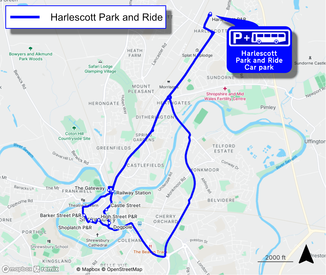
Harlescott - Car park and route map
The Harlescott Park and Ride site is located next to the Tesco Extra store at Battlefield.
Travelling from the Battlefield roundabout, take the exit towards Shrewsbury town centre. Continue along the A5112 until you reach a crossroads. Turn right at the crossroads and continue towards the mini roundabout. Take the second exit towards the signed park and ride site.
The nearest postcode to the Harlescott site is SY1 4HA (Tesco Extra, Shrewsbury).
The Harlescott Park and Ride service stops at the following locations in Shrewsbury town centre. Click on each link to be taken to a Google Maps location for each stop:
- Railway station (currently suspended due to ongoing works around the railway station gyratory)
- Castle Street (the bus shelter outside ‘Dutch Living’ is for the Oxon and Harlescott services
- Dogpole
- High Street (The Square)
- Shoplatch (Market Hall)
- Barker Street (Rowley’s House)
- The Gateway
Take a look at the Harlescott Park and Ride route map to view the full route for this service.
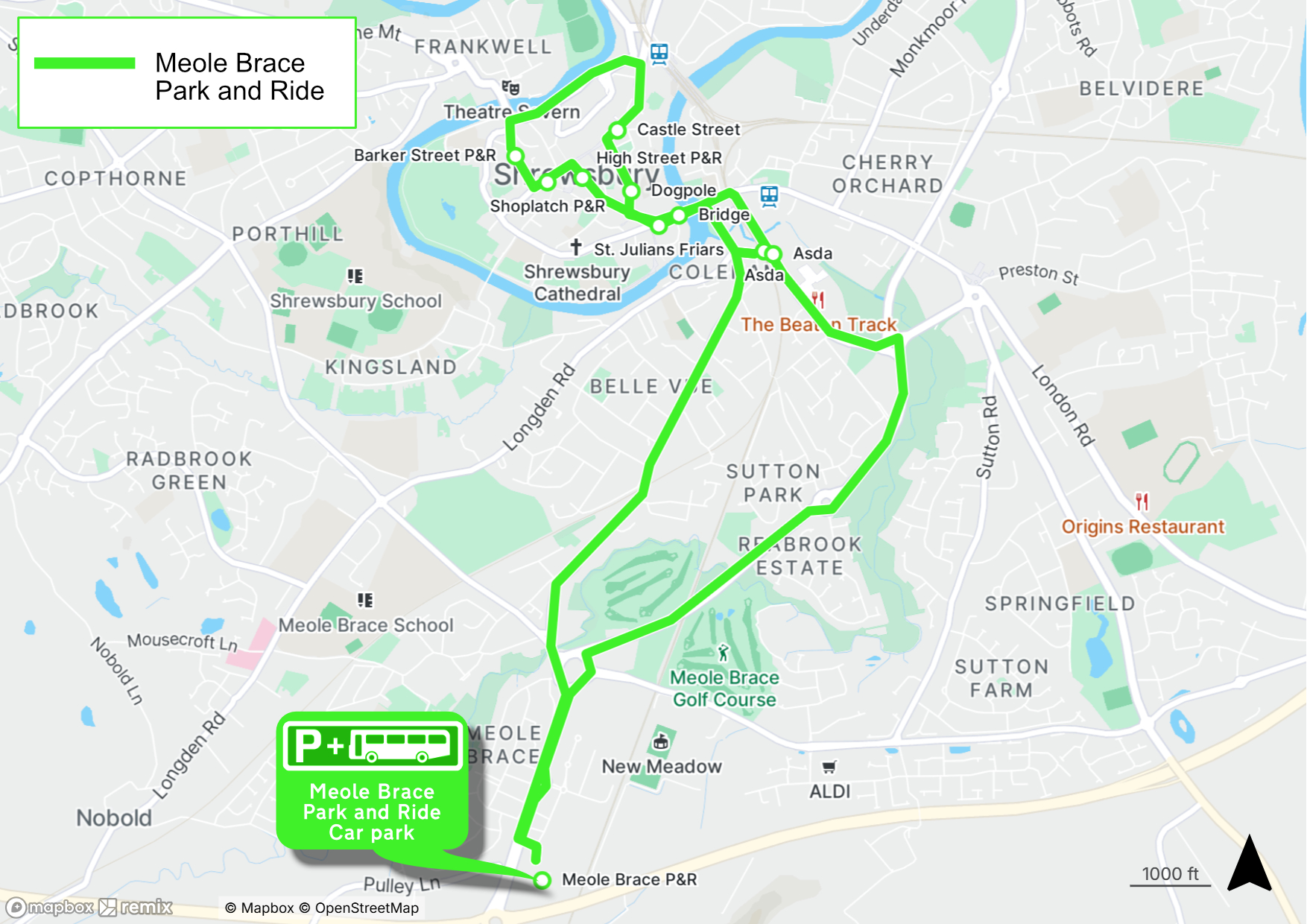
Meole Brace - Car park and route map
The Meole Brace Park and Ride site is located just south of Meole Brace Retail Park.
From Dobbie’s Roundabout, head north on Hereford Road towards Shrewsbury town centre. The entrance is at the first set of traffic lights, turning right on to the Bellway Housing Estate ‘Darwin’s Edge’. Once you've turned right at the traffic lights, follow the road to the right where you'll find the entrance to the Meole Brace site.
The nearest postcode to the Meole Brace site is SY3 9PW (Bellway development – Darwin’s Edge, Shrewsbury).
Please note that previously the entrance to Meole Brace park and ride was from Meole Brace Retail Park, near Pets at Home. This road is no longer available due to housing developments in the area.
The Meole Brace Park and Ride service stops at the following locations in Shrewsbury town centre. Click on each link to be taken to a Google Maps location for each stop:
- Old Potts Way (opposite Asda)
- St Julian's Friars
- High Street (The Square)
- Shoplatch (Market Hall)
- Barker Street (Rowley’s House)
- Castle Street (the bus shelter outside Toni & Guy’ is for Meole Brace)
- Dogpole
- English Bridge
- Old Potts Way (Asda)
Take a look at the Meole Brace Park and Ride route map to view the full route for this service.
Waiting for your bus
After parking your vehicle, passengers are reminded to wait at the designated shelter prior to the Park and Ride bus's scheduled arrival time. Passengers should not wait in their own vehicles until the bus arrives.
Bus drivers are not able to see if passengers have chosen to wait in their cars. Drivers are not permitted to wait for passengers to walk across to the shelter from their vehicle as they must depart at, or as close to, the designated time as possible.
If passengers are not at the shelter when the bus approaches, the bus will depart as timetabled.
Please note that on Saturdays between 10am and 4pm, due to pedestrianisation in the town centre, park and ride services are unable to serve stops along High Street, Shoplatch, and Barker Street. During this time, please use nearby stops such as Castle Street or Dogpole.
Routes may be disrupted at times due to road closures or events - information will be supplied at bus shelters and/or via social media platforms if relevant.